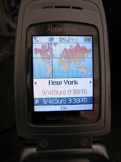
This is a screenshot from my old phone's fancy 'time zone' feature.
Lets look a little closer at that map, it certainly looks a lot like the mercator projection according to the shape of the continents.
Notice how the real shapes of Alaska and northern Eurasia are preserved, though their areas are exaggerated. This shows that it is a mercator projection. For an easy comparison I've included a mercator earth map from Wikipedia below. Take a closer look at the latitude grid-lines, notice how they are spaced further apart near the poles because of the map is stretched in the direction of latitude.
Now look back at the the cell phone map, we can see that the longitude/latitude grids-lines are perfect squares meaning somebody at the kyocera corporation said "we need to have gridlines" but the person implementing it did not know what type of map they were projecting.
Should I be upset?


I think you're lucky they included a map. Maybe they should have used one of the map projections in this XKCD comic, or any of these projections.
ReplyDeleteWhat kind of projection makes every gridline perfect square?
ReplyDeleteThat kind of map is actually called "no projection" because its not a projection, just x=longitude, y=latitude. See some examples here
ReplyDeleteYeah, their projection is clearly not this one.
ReplyDeleteInteresting observation. Not many people pay attention or care for this kind of thing. Also, I feel much better knowing that I'm not the only person that still uses a flip phone!
ReplyDelete